Metro Safar
Find Nearest MetroMetro Maps

Metro cities

Delhi MetroBangalore MetroChennai MetroHyderabad MetroKolkata MetroDubai Metro

Official Transit Portals

Delhi MetroGurgaon MetroNoida MetroJaipur MetroMumbai MetroBangalore MetroHyderabad MetroChennai MetroKochi MetroKolkata MetroLucknow MetroNagpur MetroAhmedabad MetroPune MetroIndore MetroBhopal MetroKanpur MetroAgra MetroDubai Metro
Note: Metro Safar is an independent metro travel guide. We help you check fares, routes and timings across metro cities. We are not affiliated with any metro corporation. Please confirm schedules on official metro apps or websites.
Metro Safar Logo
HomeMetro MapsNearest metroAbout UsTravel rulesContact UsDisclaimerPrivacy PolicyTerms of Use

© 2026 Metro Safar. All rights reserved.

Made for daily metro travel
HomeNagpur MetroNetwork Map
Nagpur Metro map

Nagpur Metro Map

Interactive route map and high-resolution line diagrams for Nagpur Metro.

Data checked: 28 Oct 2026 · Confirm on official metro site before travel Nagpur Metro official site
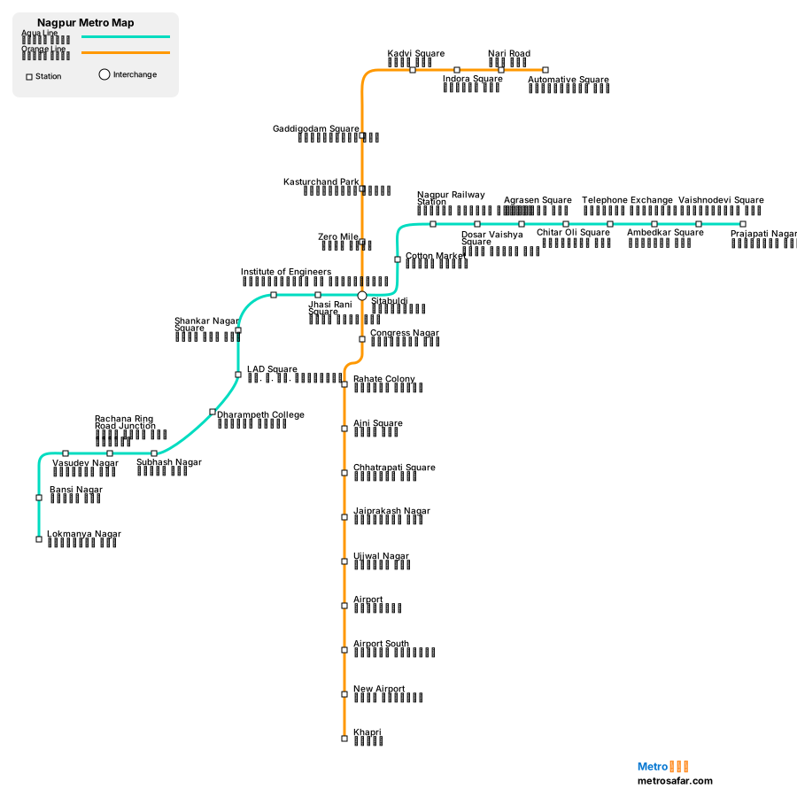
Interactive Pan & Zoom Enabled
100%
Nagpur Metro Map

Metro Line Map

Aqua Line Map
Open Map →
Orange Line Map
Open Map →

Station Directory Search

Agrasen Square (अग्रसेन चौक)
Airport (विमानतळ)
Airport South (दक्षिण विमानतळ)
Ajni Square (अजनी चौक)
Ambedkar Square (आंबेडकर चौक)
Automative Square (ऑटोमोटिव्ह चौक)
Bansi Nagar (बंसी नगर)
Chhatrapati Square (छत्रपती चौक)
Chitar Oli Square (चितारओळी चौक)
Congress Nagar (काँग्रेस नगर)
Cotton Market (कॉटन मार्केट)
Dharampeth College (धरमपेठ महाविद्यालय)
Dosar Vaishya Square (दोसर वैश्य चौक)
Gaddigodam Square (गड्डीगोदाम चौक)
Indora Square (इंदोरा चौक)

Nagpur Metro map FAQ

Where can I see the Nagpur Metro route map?

Interactive route map and high-resolution line diagrams for Nagpur Metro.

How do I download the Nagpur Metro map?

Use Download map on this page to save a PNG of the Nagpur Metro network map for offline viewing. Line pages also offer a download for that corridor.

How do I open a single Nagpur Metro line map?

Scroll to Metro Line Map and open any coloured line (for example Aqua Line). Each line page shows an interactive route map, terminals, interchanges, and the full station sequence.