Metro Safar
Find Nearest MetroMetro Maps

Metro cities

Delhi MetroBangalore MetroChennai MetroHyderabad MetroKolkata MetroDubai Metro

Official Transit Portals

Delhi MetroGurgaon MetroNoida MetroJaipur MetroMumbai MetroBangalore MetroHyderabad MetroChennai MetroKochi MetroKolkata MetroLucknow MetroNagpur MetroAhmedabad MetroPune MetroIndore MetroBhopal MetroKanpur MetroAgra MetroDubai Metro
Note: Metro Safar is an independent metro travel guide. We help you check fares, routes and timings across metro cities. We are not affiliated with any metro corporation. Please confirm schedules on official metro apps or websites.
Metro Safar Logo
HomeMetro MapsNearest metroAbout UsTravel rulesContact UsDisclaimerPrivacy PolicyTerms of Use

© 2026 Metro Safar. All rights reserved.

Made for daily metro travel
HomeAhmedabad MetroNetwork Map
Ahmedabad Metro map

Ahmedabad Metro Map

Interactive route map and high-resolution line diagrams for Ahmedabad Metro.

Data checked: 28 Oct 2026 · Confirm on official metro site before travel Ahmedabad Metro official site
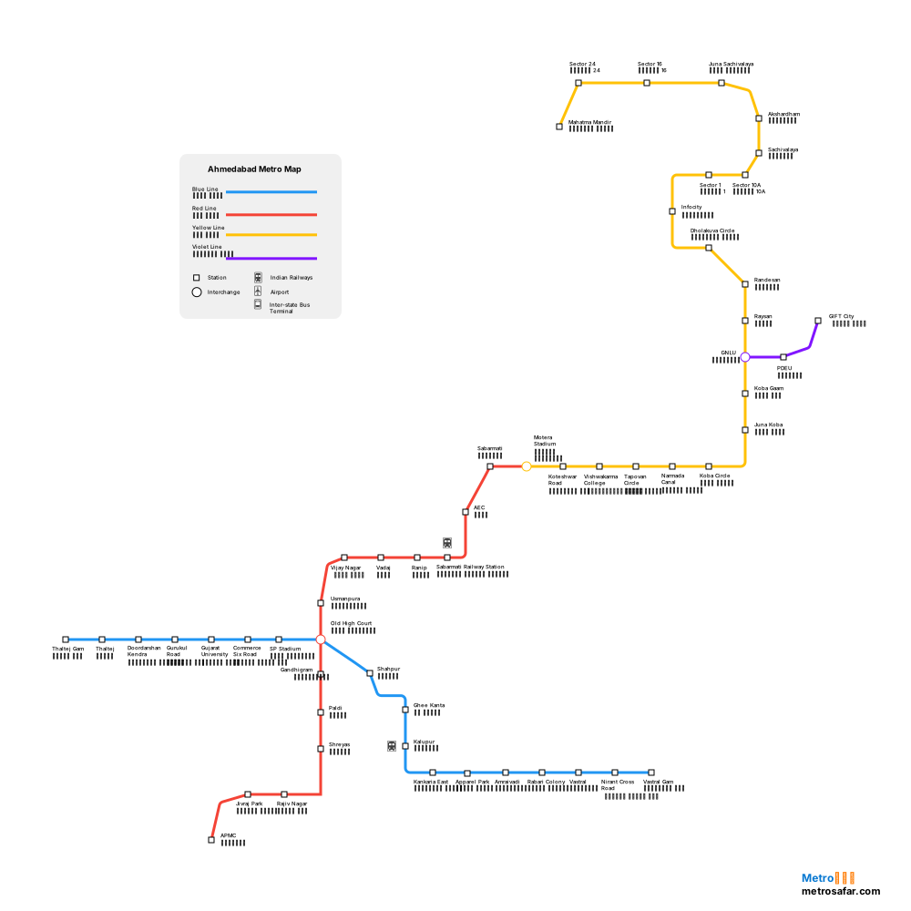
Interactive Pan & Zoom Enabled
100%
Ahmedabad Metro Map

Metro Line Map

Red Line Map
Open Map →
Yellow Line Map
Open Map →
Blue Line Map
Open Map →
Violet Line Map
Open Map →

Station Directory Search

AEC (एईसी)
APMC (एपीएमसी)
Akshardham (अक्षरधाम)
Amraivadi (अमराईवाड़ी)
Apparel Park (एपैरल पार्क)
Commerce Six Road (कॉमर्स सिक्स रोड)
Dholakuva Circle (ढोलकुवा सर्कल)
Doordarshan Kendra (दूरदर्शन केन्द्र)
GNLU (जीएनएलयू)
Gandhigram (गांधीग्राम)
Ghee Kanta (घी कांटा)
Gift City (गिफ्ट सिटी)
Gujarat University (गुजरात विश्वविद्यालय)
Gurukul Road (गुरुकुल रोड)
Infocity (इन्फोसिटी)

Ahmedabad Metro map FAQ

Where can I see the Ahmedabad Metro route map?

Interactive route map and high-resolution line diagrams for Ahmedabad Metro.

How do I download the Ahmedabad Metro map?

Use Download map on this page to save a PNG of the Ahmedabad Metro network map for offline viewing. Line pages also offer a download for that corridor.

How do I open a single Ahmedabad Metro line map?

Scroll to Metro Line Map and open any coloured line (for example Red Line). Each line page shows an interactive route map, terminals, interchanges, and the full station sequence.